Information about the MidCoast region, from Ellenborough Falls to the north shore of Port Stephens, and from the Great Lakes to Barrington Tops
The MidCoast
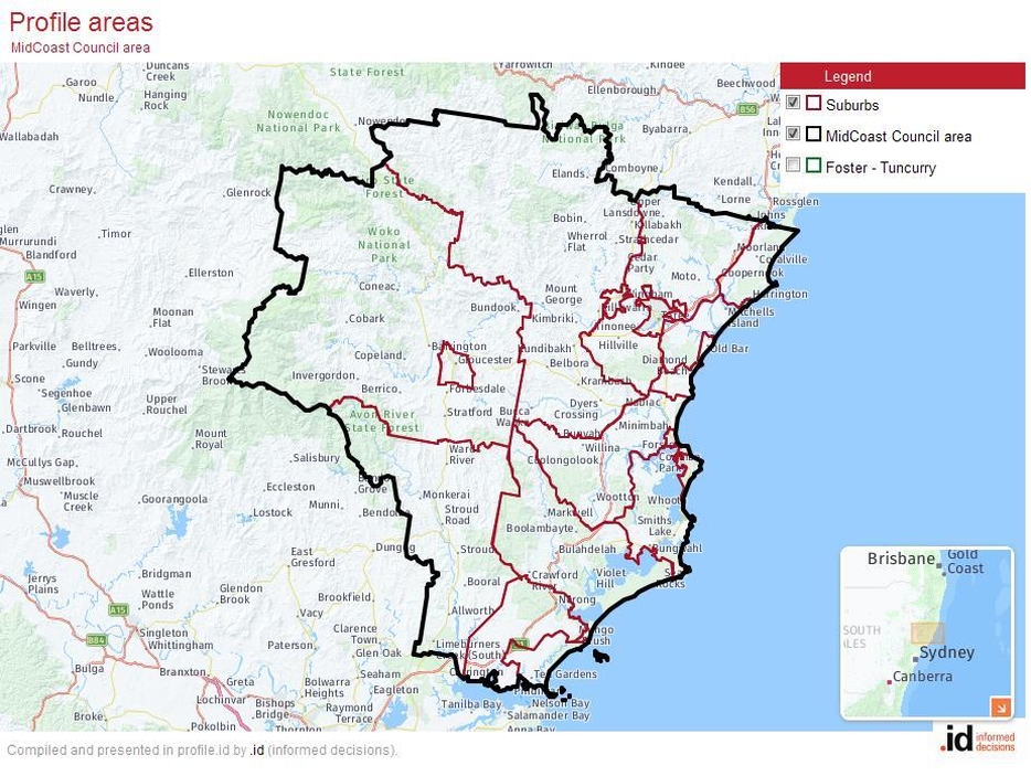
For a basic description of the MidCoast region, including the map, we draw on the profile of the MidCoast Local Government Area produced by .id (informed decisions) for MidCoast Council.
The original inhabitants of the MidCoast Council area are the Biripi and Worimi people. We acknowledge the traditional owners and pay respect to their Elders past and present.
Located on the mid-north coast of New South Wales in the State's Hunter Region, the total land area of the MidCoast Local Government Area is 10,060 square kilometres. It has an Estimated Residential Population for 2020 of 94,395. The population is forecast to grow to 113,147 by 2036.
European settlement began in the 1820s, with sheep farming and timber-getting as early occupations. Stroud was built with convict labour in the 1820s and 1830s as a company town for the Australian Agricultural Company. Wingham was established in 1843 as a river port on the Manning, and Gloucester was surveyed in 1855. In the decades since then, development has been spurred on by factors such as successes in the dairy farming, timber milling and ship building industries, the discovery of gold at Copeland, and the opening (in 1913) of the north coast railway line .
Since the 1960s, improved access and increased tourism has led to continued growth in the coastal areas in particular. The rainforests in Barrington Tops National Park are part of the Gondwana Rainforests of Australia World Heritage Area, declared in 1986.
Water Catchments
|
Louise Duff, Catchment Management Coordinator at MidCoast Council, provides an overview of the water catchments of the MidCoast region, and their importance to growers
|
Water is life…we share the river as a central part of the wild ecosystem that provides habitat for wildlife from iconic animals to the tiniest microbes. |
Rivers connect our landscape and communities
Chances are if you’re a gardener you’re tuned into not just your own patch, but also the landscape and waterways around you. Every garden is part of a wider catchment that feeds water into our rivers, known as bila in the local Gathang language. These rivers are the lifeblood of our community. From the mountains to the sea (Balgarr-abirang-Gurrwa-gu), from freshwater to saltwater (Bathu-garibang-Girambit-gu) - the rivers connect our landscape and our communities.
Chances are if you’re a gardener you’re tuned into not just your own patch, but also the landscape and waterways around you. Every garden is part of a wider catchment that feeds water into our rivers, known as bila in the local Gathang language. These rivers are the lifeblood of our community. From the mountains to the sea (Balgarr-abirang-Gurrwa-gu), from freshwater to saltwater (Bathu-garibang-Girambit-gu) - the rivers connect our landscape and our communities.
|
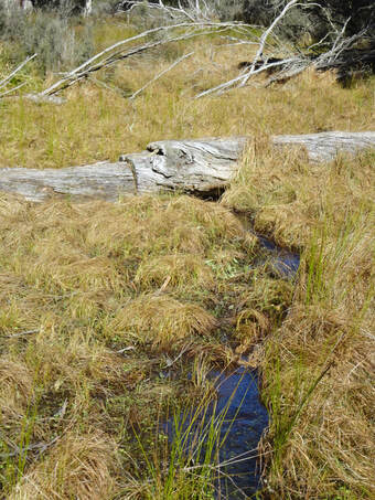
The mighty Manning River (Djari Bila) originates at 1,570m above sea level in the Gondwana World Heritage Area of the Barrington Tops and flows 261 km to the Tasman Sea. Its vast catchment covers approximately 8,420km2 with 16 major tributaries.
Further south, the Myall River flows into the internationally significant Myall Lakes before wending its way to its mouth at Hawks Nest on Port Stephens. The Karuah River flows over 100km, also into Port Stephens. Along the way, freshwater wetlands and groundwater aquifers contribute to the base-flow of rivers. Groundwater is intimately connected with surface water, providing a reliable source of water to many ecosystems and supplementing our drinking water supply at the Nabiac bore field. |
Barrington Tops, source of rivers (photo: Ron Woods)
|
Riparian zones, the interface between land and water, are particularly biodiverse. Some animals like the platypus are riparian specialists, while others such as bass and the Manning River helmeted turtle depend on inputs from the riparian zone for food and shelter. The shady, cool and moist habitat of riparian zones and availability of water provides crucial refuge for terrestrial wildlife such as koalas to minimise stress during drought and heatwaves. This function will become more important as the climate changes.
Our precious freshwater rivers provide water for drinking, gardening, stock and irrigation. We love the cool water and tranquil scenery, feeling a cultural and spiritual connection. They flow into the beautiful coastal lakes and estuaries where fresh and saltwater meet. Estuaries are the 'nurseries of the sea'. Their sheltered waters provide vital nesting, breeding and feeding habitats for many species of fish, shellfish, aquatic plants and birds. All these values depend on healthy ecosystems and clean water.
Our precious freshwater rivers provide water for drinking, gardening, stock and irrigation. We love the cool water and tranquil scenery, feeling a cultural and spiritual connection. They flow into the beautiful coastal lakes and estuaries where fresh and saltwater meet. Estuaries are the 'nurseries of the sea'. Their sheltered waters provide vital nesting, breeding and feeding habitats for many species of fish, shellfish, aquatic plants and birds. All these values depend on healthy ecosystems and clean water.
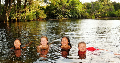
Kids' river, Gloucester (photo: Louise Duff)
MidCoast Council has worked together with stakeholders to develop management plans for each of our catchments, the most recent being the Manning River Estuary and Catchment Management Program. These plans guide collective action to improve the health and resilience of our rivers and estuaries, taking a whole-of-catchment approach. Our vision:
Rivers, tributaries and the estuaries give life to our community, connecting the mountains to the sea. Together we manage catchments holistically and respond to a changing climate - safeguarding environmental, social, cultural and economic values.
Rivers, tributaries and the estuaries give life to our community, connecting the mountains to the sea. Together we manage catchments holistically and respond to a changing climate - safeguarding environmental, social, cultural and economic values.
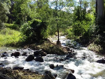
From Sawpit Creek (in flood) into Copeland Creek, Barrington River, Gloucester River, and then into the mighty Manning (photo: Ron Woods)
|
The health of our rivers and estuaries is intimately connected to the health of land in our catchments. As gardeners and growers, every step you take to hold water in your landscape is helping maintain the catchment where you live. Improving ground cover and soil organics improves water infiltration and helps stop diffuse source run-off of sediments and nutrients that pollute our rivers.
Creating a healthy reed zone around your dams and restoring coastal and freshwater wetlands helps nature do its job - storing water, recharging aquifers and filtering pollutants. Tree cover provides shade for livestock away from watercourses, drives the local water cycle and hydrates the landscape. |
Maintaining native vegetation, especially on riverbanks, provides habitat for aquatic fauna, prevents bank erosion and takes up nutrients before they reach the water. Minimising the use of pesticides helps improve the productive life of the soil, and keeps waterways clean.
Growers have nature in their souls. They feel the dirt, sniff the wind, nurture seeds, grow food, and build connected, nurturing communities. When you’re gardening on your patch, look up, look around and think about how your efforts can help maintain healthy catchments, rivers and estuaries. |
To stay in touch with MidCoast Council’s environmental news and events, subscribe to the Creeks-to-Coast newsletter.
Louise Duff, 2021 |
Climate change and the Midcoast
Re-vegetated dunes at Old Bar - Photo: Ron Woods
|
The NSW Government Department of Environment and Heritage produced a series of climate change snapshots for regions of the state in 2014.
Our region is included in the North Coast Region Snapshot. The link to the text is provided below. Key points: |
- Based on long-term (1910–2011) observations, temperatures have been increasing in the North Coast Region since about 1970, with higher temperatures experienced in recent decades.
- Compared to recent years (1990–2009), the Region is projected to continue to warm in the near future (2020–2039) and far future (2060–2079), . The warming is projected to be on average about 0.7°C in the near future, increasing to about 2°C in the far future.
- Minimum temperatures are projected to increase by 0.5 – 1.0°C in the near future ; and by 1.6 – 2.5°C in the far future.
- The number of hot days (above 35 degrees) will increase, and the number of cold nights (below 2 degrees) will decrease.
- Rainfall is projected to decrease in winter and to increase in autumn and spring, with the climate models for summer being just about evenly divided as to whether the trend is towards drying or wetting scenarios.
- Based on the Forest Fire Danger Index (FFDI), 'Average' fire weather is projected to increase in summer and spring. 'Severe' fire weather days are projected to increase in summer and spring, but to decrease in autumn.
Towns and Districts
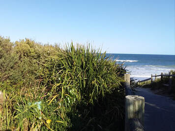
Bulahdelah
Bulahdelah is the western access point to the Myall Lakes National Park, which is the largest natural freshwater lake system on the NSW coast. The name (most likely a Worimi Aboriginal word referring to 'the meeting place of two rivers') was first given to the mountain to the east of the town, called Mount Bulladella by the explorer and surveyor John Oxley in 1818. The area around the mountain was declared a state forest reserve - Bulahdelah Mountain Forest Park - in 1979. Although it is now bypassed by the Pacific Highway, the town remains an attractive place for people to stop on their journeys north and south due to its many services and shops, and to its lush surrounds.
Bulahdelah is the western access point to the Myall Lakes National Park, which is the largest natural freshwater lake system on the NSW coast. The name (most likely a Worimi Aboriginal word referring to 'the meeting place of two rivers') was first given to the mountain to the east of the town, called Mount Bulladella by the explorer and surveyor John Oxley in 1818. The area around the mountain was declared a state forest reserve - Bulahdelah Mountain Forest Park - in 1979. Although it is now bypassed by the Pacific Highway, the town remains an attractive place for people to stop on their journeys north and south due to its many services and shops, and to its lush surrounds.
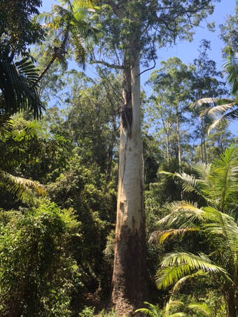 Grandis Flooded Gum (photo: Ron Woods)
One of the district attractions is the Grandis Flooded Gum. At a height of 76.2 metres, this 400 year-old Eucalyptus grandis is the tallest publicly accessible tree in NSW. Soaring up above the forest canopy, with a diameter of 11.5 metres at ground level, it is a sight to behold.
The Lakes Way continues on from the Grandis turnoff to pass through the forests around Bulahdelah, including in the Wallingat National Park. On the way to Forster, there is a turnoff to Seal Rocks.
Bulahdelah is also famous for its Clydesdales. Going on a farm tour to Bulahdelah Clydesdales, you can learn more about these gentle giants that were so vital in the development of rural Australia. In town, the old courthouse (1886), now housing the Bulahdelah Historical Society, is well worth a visit. Strolling along the Myall River is a pleasure in itself.
Copeland
Copeland is a small community with a big history. In 1875, red cedar cutters - who had been logging the area for decades already - discovered gold in this hilly area not far west of Gloucester. The gold rush area soon became known as Copeland, named after Henry Copeland (1839-1904), a politician and mining expert. Visitors can today go on guided tours of some of the old mines at Copeland, which can be booked at online with National Parks of NSW. The prominent feature of the district is Copeland Tops, part of the foothills of Barrington Tops.
Copeland is a small community with a big history. In 1875, red cedar cutters - who had been logging the area for decades already - discovered gold in this hilly area not far west of Gloucester. The gold rush area soon became known as Copeland, named after Henry Copeland (1839-1904), a politician and mining expert. Visitors can today go on guided tours of some of the old mines at Copeland, which can be booked at online with National Parks of NSW. The prominent feature of the district is Copeland Tops, part of the foothills of Barrington Tops.
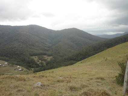
Looking towards Copeland Tops from the north-east (photo: Ron Woods)
The Copeland Tops State Conservation Area occupies the major part of this natural feature, and it contains some magnificent bushwalks within accessible tracts of dry rainforest. A feature of these forests is the prominence of epiphytes, such as bird's nest ferns and orchids, and there are also lovely stands of Australian grass trees (Xanthorrhoea sp.). The settlement of Copeland, much reduced in size since the gold mining days, lies at the base of the Tops, and houses are pleasantly spaced out along Copeland Creek. The closest shops are in Barrington and Gloucester, a short drive away. The district also boasts several established farms and acreages .
Please share your own descriptions of MidCoast towns and districts with other growers |
Please send through your descriptions of towns, suburbs, villages and districts in the MidCoast region. Not long - two para's and a photo. With that, we can build up a picture of the region through the eyes of its growers.
Contact us with your ideas and your stories at midcoastgrowersnetwork@gmail. com |
